

New draft zoning maps spark debate over disparities in density
The first draft maps of Richmond’s new zoning districts are out, and two of the biggest issues concerning reviewers are where density is — and isn’t — being encouraged and how high mixed-use buildings along key transportation corridors should be allowed to rise.
At a meeting last week of the city’s Zoning Advisory Council, a collection of developers, land use experts and ordinary residents who are helping guide the zoning overhaul, Councilor Ellen Robertson (6th District) worried that the new maps encourage the greatest density in predominantly Black or low-income neighborhoods while letting those with more white and wealthy residents go mostly untouched.
“Density seems to be being found more favorable in neighborhoods that are historically African American communities and also, historically, communities that may have been disenfranchised by redlining,” said Robertson.
“I really do feel like there’s a huge, huge disparity in zoning,” she continued. “And I seriously would ask us to go back in and consider this.”
That perception was echoed by several other participants at the June 11 meeting. Joseph Carlisle, a leader of pro-housing, pro-density group RVA YIMBY, called it “deeply frustrating that exemptions from growth are being considered for the most educated, affluent and opportunity-rich neighborhoods of our city.”
“No neighborhood should be exempt from change, and no single neighborhood should have to be subject to all of the city’s change. Every neighborhood should have to do their part,” he told the council.
ZAC member Elizabeth Hancock Greenfield, who also serves as vice chair of the Planning Commission and vice president of public affairs for the Home Building Association of Richmond, agreed the density envisioned by the draft maps is not distributed equally around the city.
“I think we’re all aware … of the areas that are not getting the levels of density, and they’re more in the western end of the city, where we’ve spent a lot of time going over the duplex, triplex, accessory unit conversation,” she said. “So I think that’s the easy area to say where the density is not going.”
While zoning designations will not affect already constructed buildings, which can continue to exist unchanged, they will set the rules for new development, meaning that over time they can change the way neighborhoods look and function.
Residential areas, because they are home to the most important assets people own, tend to provoke the greatest emotions.
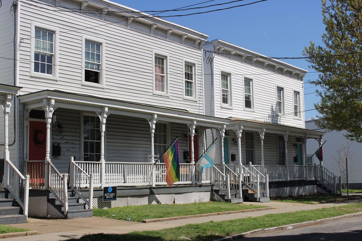
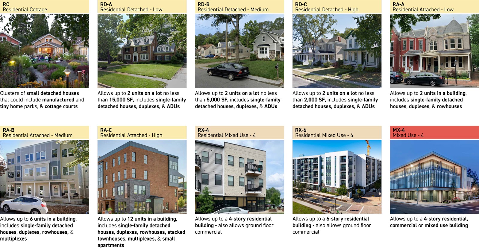
Under the proposed zoning districts — which officials have repeatedly emphasized are not final — those neighborhoods are generally classified as either residential detached or residential attached, depending on whether the buildings are mostly freestanding or connected to one another. Further designations dictate the level of density allowed based on factors like lot size and width, how far the building is set back from the street, height and number of units.
Robertson suggested many of the denser areas on the map, including those zoned for mixed use and as RD-C, match areas redlined in the 1930s as the least desirable neighborhoods — a contemporary shorthand for areas with large numbers of Black and immigrant residents.
Meanwhile, much of the West End and the southwestern part of the city would continue to have some of the most restrictive zoning, RD-A, ensuring their neighborhoods would remain dominated by large lots and single-family homes.
“Where we are showing the willingness to increase density is not equitable,” Robertson said. “It is concentrated and it follows the principles of the existing zoning of the city of Richmond.”
Rene Biberstein of Code Studio, a consultancy Richmond has hired to help with the code refresh, said planners “certainly don’t want to do what you’re suggesting.”
According to Biberstein, the draft map is based on not only the future land uses envisioned in the city’s Richmond 300 master plan but also neighborhoods’ current zoning and lot patterns. In some areas, zoning was adjusted to match existing development that doesn’t conform with the zoning rules on the books.
“It’s mostly about trying to bring that into conformity,” he said. “It’s not really supposed to be about taking areas where everybody has a larger lot and allowing them to divide it up into a whole bunch of small lots.”
“That’s the intention behind it,” he said. “But we certainly can take a look at it again.”
ZAC member Philip Hart, a real estate attorney for Genworth Financial, said while he believes the RD-C zoning “does create an incentive for developers to purchase less expensive lots to convert them into much denser uses,” the answer is not spreading the RD-C zoning to other parts of the city. Instead, he said planners should consider increasing the minimum lot width in that zoning designation.
“You could put R-DC in the most expensive parts of the city, and the cost of land would be such that people wouldn’t develop it,” he said.
Meanwhile ZAC member Eric Mai, a vice president for affordable housing and community development consultancy HDAdvisors, urged planners to consider incorporating racial equity as a “guiding principle” of the zoning refresh, pointing in particular to how the cities of Charlottesville and Alexandria approached their rewrites (both of which were controversial).
Allowing more density in all neighborhoods by permitting three-family housing units in all residential zones is “a matter of equity and opportunity,” said Mai. “I think this is a rare opportunity to address that.”
Mixed-use corridors
Still, members of the ZAC continue to disagree on a key point: whether increasing density through the zoning code will result in an increase of affordable housing.
For many, the link between the two is clear: More supply means lower prices. In their view, greater density is critical if the city is to combat COVID-era housing price spikes and an influx of residents from higher-income cities like Washington, D.C. Those rises, which are occurring nationwide, are increasingly pricing out younger adults — last year, the median age of first-time homebuyers in the U.S. was 38, compared to 29 in 1981 — and have put many lower-income residents in a precarious position as they face steep real estate tax bills due to skyrocketing assessments.
“We don’t build enough homes to meet demand, and the primary reason for that is our current zoning from the 1970s,” which is “zoned primarily for single family, detached residential homes,” resident Andrew Bryant told the advisory council. “It locks in inequitable development.”
But others are skeptical. Much of the new housing being built, they point out, comes at a high cost.
“I understand the need for more housing, and I totally support it. However, it must also be affordable housing,” said Nora Thompson, a resident of the Henry Place neighborhood that lies just west of Interstate 195 near Carytown, as she argued against the rezoning of her area to RD-C.
ZAC member and VCU professor Damian Pitt called concerns that new housing being built is too expensive “valid.” But, he continued, “it’s one thing to say that new development is expensive relative to the old preexisting development that was in that same neighborhood, but it’s not necessarily more expensive compared to what new development could be built under the existing zoning.”
Brian White, another ZAC member who also serves on the Planning Commission and is a real estate developer with local firm Historic Housing, LLC, insisted that even if new development is more expensive, “it still absolutely helps.”
“It provides downward pressure,” he said.
Many members of the ZAC have argued that one key place density should go is along key streets identified as transit corridors. While earlier worries about building heights led planners to cap much mixed-use zoning along those stretches of road at three stories, council members repeatedly pushed for those limits to be lifted in comments on the draft map.
The Richmonder is powered by your donations. For just $9.99 a month, you can join the 1,000+ donors who are keeping quality local journalism alive in Richmond.
For Robertson, increasing density along transit corridors would allow some of the pressure to be lifted from residential neighborhoods even as the city works to encourage more affordable housing development.
“If we are going to try to increase density by just doing it in residential zones in certain neighborhoods … and be very sparing in our commercial corridors, not allowing more than three stories, then this map is not designed to provide the level of density and inclusion that it needs to,” she said.
Hart similarly suggested that focusing density on corridors would “impose less dislocation in traditional single-family neighborhoods.”
As a compromise, Biberstein said the consultants were considering using three-story mixed-use zoning “sparingly” when it backs up to low-lying residential neighborhoods while allowing four- and six-story mixed-use along corridors and eight stories at “significant intersections” and proposed bus rapid transit stops.
That idea seemed to gain broader support last week.
Four-story mixed use, reflected ZAC member Charlie Wilson, “might not be as scary as some people might think.” And architect Dave Johannes accused generations of Richmonders of being “acrophobic,” or afraid of heights.
“Those heights sound high, but they’re not,” he said.
The Planning Department is holding three open houses on the draft districts and maps next week. Details can be found here.
Contact Reporter Sarah Vogelsong at svogelsong@richmonder.org


