
Here’s Richmond’s first crack at designing a new Mayo Bridge
The first detailed plans for how a new Mayo Bridge could look are out — and they drew both praise and dismay from the city’s Urban Design Committee Thursday.
At the top of the committee’s list of kudos: the reduction of the number of vehicle lanes on the bridge from four to two, a decision that committee chair Justin Doyle called “a huge perk of the project.”
But members were less enthusiastic about the plan’s lack of any physical barriers between the two bike lanes and the vehicle lanes that would adjoin them. That absence, said several, would unnecessarily put bikers at risk — even as city fire officials said barriers were a no-go because they would block drivers from moving out of the way in case of an emergency.
“Paint is not protection,” said UDC member Keith Van Inwegen. “There has to be some way to do it. Otherwise we shouldn’t even call these bike lanes.”
The conceptual review that the committee was charged with carrying out Thursday is just the first step in a much longer design process that isn’t expected to wrap up until early 2027, when officials anticipate getting final approval. Another immediate step is necessary: The Richmond Planning Commission will have to sign off on the plans and a slate of recommendations put forward by the UDC next week.
But if approved, those conceptual designs will “confirm the overall direction of the project and … establish the key design features that will be carried forward into detailed design,” said Richmond Bridge Engineer John Kim in an email.
“These include elements such as the overall bridge width, arches, parapet, general appearance and character, sidewalk widths, number of travel lanes, dedicated bike lanes, streetlight type, the Mayo Island Park intersection, and the inclusion of overlooks,” he continued. “These core elements are expected to remain consistent through design development and final [Planning Commission] approval.”
Will Wheeler, the project manager who is overseeing the bridge replacement at the Virginia Department of Transportation, described the approach as “marrying a city approval process with a VDOT design-build process.”
Built in 1913, the Mayo Bridge connects Shockoe Bottom in the north with Manchester in the south, punctuated by a stopover on Mayo Island midway through. The Federal Highway Administration has classified the bridge’s condition as poor, and in 2024 city and state officials determined full replacement was necessary.
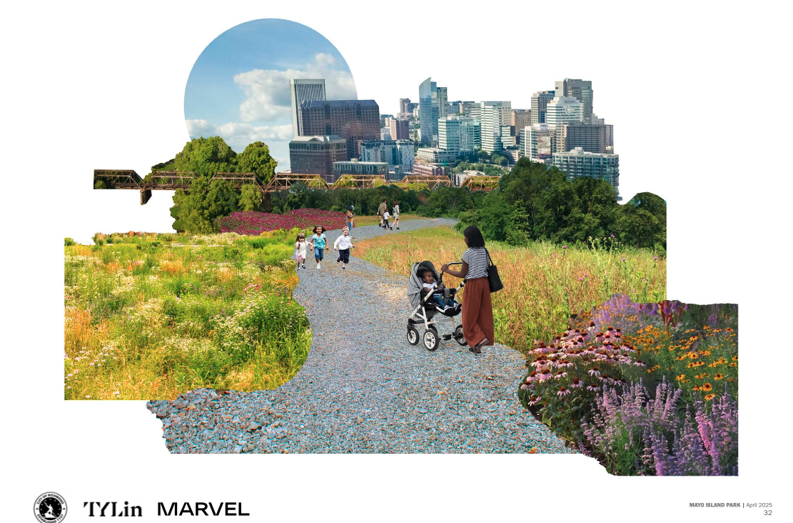
Today the project carries an estimated price tag of over $190 million, of which $88 million still needs to be funded. Besides serving the busy Manchester and Shockoe Bottom neighborhoods, the new bridge will also link to a new 15-acre public park the city is building on Mayo Island and feed into the Manchester Canal Bridge, which is also slated for replacement.
“This bridge is a connector,” said Janet Woodka, head of neighborhood group the Manchester Alliance. “It should be something that we think about both in terms of the fact that there’s a park in the middle of this bridge which people are going to want to go to, but it is also an economic driver.”
Here are several key parts of the design being considered:
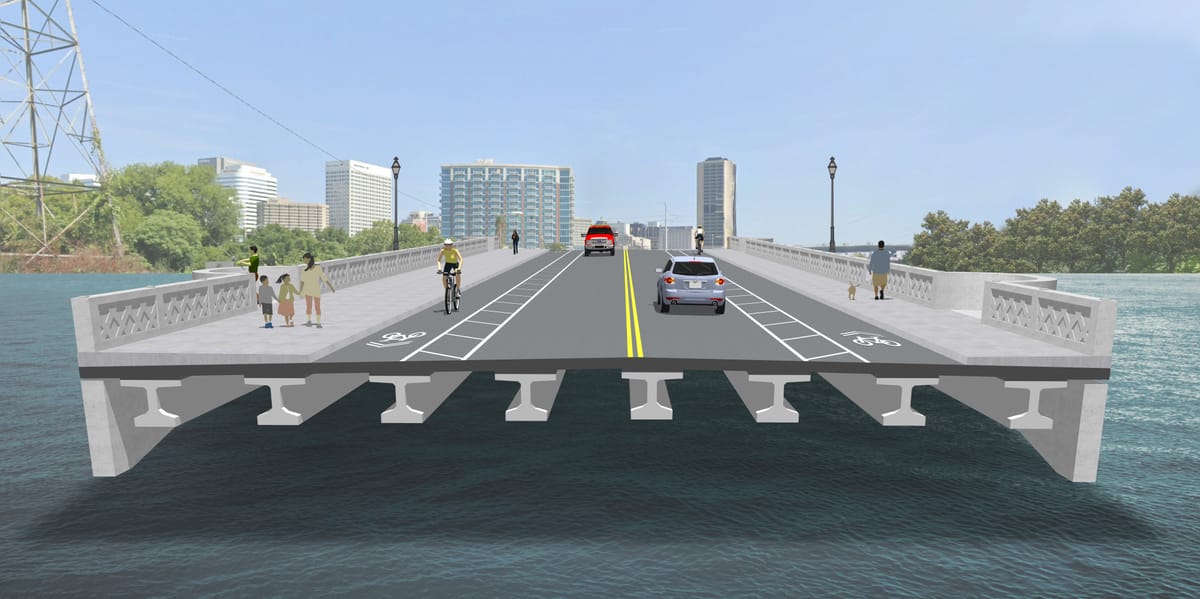
Car, bike and pedestrian lanes
The city and VDOT are suggesting a 66-foot-wide bridge that sits east of the current location and includes a bend partway through as a way to slow traffic. The speed limit will also be dropped from its current 35 mph to 25 mph.
Right now, “people see the bridge as one long, straight thoroughfare,” said Wheeler. “By putting a bend in the bridge, we actually can introduce traffic calming measures.”
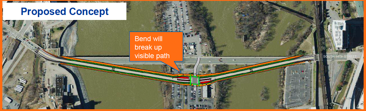
Situating the new bridge on a different footprint will also allow the current bridge to stay open longer during construction, reducing the amount of time detours have to be in place.
The new bridge would be made up of two vehicle lanes, two bike lanes and two sidewalks. At 14 feet wide, the western sidewalk would be much bigger than the 8-foot-wide eastern sidewalk because of its connections to surrounding trails, although the UDC is recommending that planners reconsider that configuration.
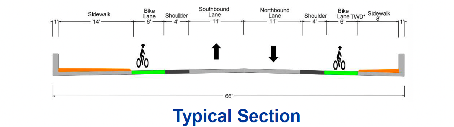
By far the biggest point of dispute Thursday was how the bike lanes should be protected from vehicle traffic.
The Richmond Fire Department has argued that physical barriers will prevent cars from getting out of the way of fire trucks in emergency situations, potentially slowing down critical response times. With only one vehicle lane in each direction, fire officials said the bike lanes will become pull-off areas in those circumstances.
Right now, fire department vehicles cross Mayo Bridge about 14 times a day, said RFD engineer Anthony Jones.
“In an emergency when we’re trying to come through, we need traffic to move to the right,” he said.
UDC members urged planners to come up with another solution, floating a range of ideas such as rumble strips, planter boxes spaced at intervals and low-relief quick curbs.
Members of the public who offered comments also argued some type of barrier was needed.
“There’s no reason that we cannot ask our engineers to be safe, provide the fire department what they need and still protect the pedestrian and bike lanes,” said Charles Macfarlane, a real estate developer who has been active in Shockoe Bottom.
Mayo Island bus stop and crossing
To accommodate the much higher number of visitors to Mayo Island that are expected when it opens as a park, the plans call for northbound and southbound bus stops along with wider sidewalks. (The city expects to offer a parking lot for some cars on the island, but those plans are still under development.)
Because pedestrians would have to cross traffic to move between the eastern and western portions of the island, officials are planning to install flashing beacons that alert drivers to the presence of people on foot and to elevate the portion of road where the crossing will be located.
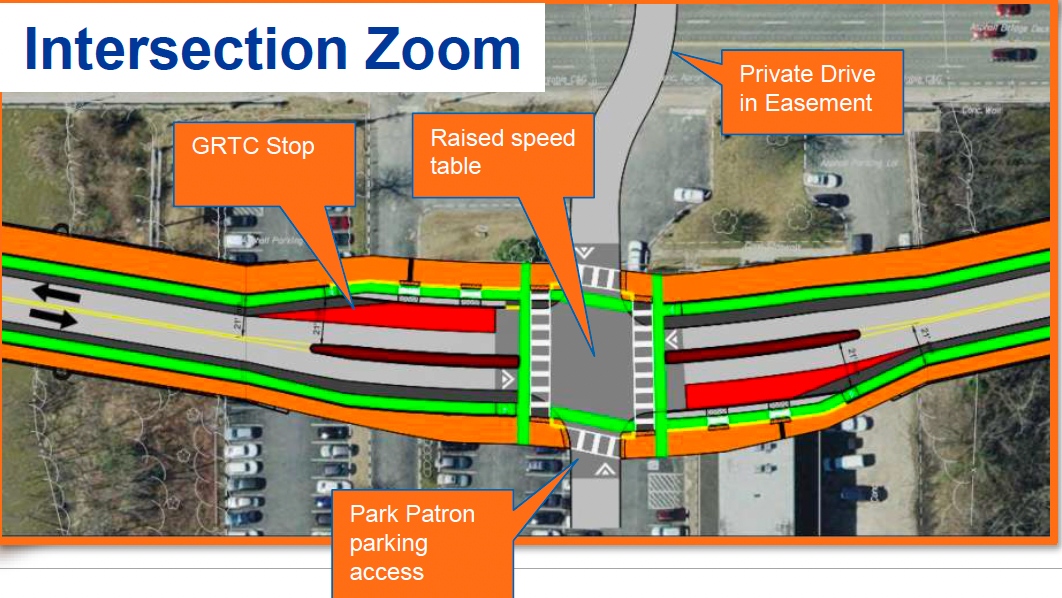
Still, the layout caused some concern among the UDC, with member Jessie Gemmer saying she was “pretty panicked thinking about hundreds of people being in this park and crossing the road.”
Gemmer asked whether the city and VDOT had considered raising Mayo Bridge when it crosses the island so that pedestrians could be routed underneath it without needing to interact with traffic.
Wheeler, however, said that design would diverge significantly from the bridge’s historic layout and, more importantly, would cause a rise in the river under flood conditions — an outcome that is prohibited under the terms of one of the grants that let the city purchase the island.
The UDC is recommending that planners explore additional ways to make the pedestrian crossing safer.
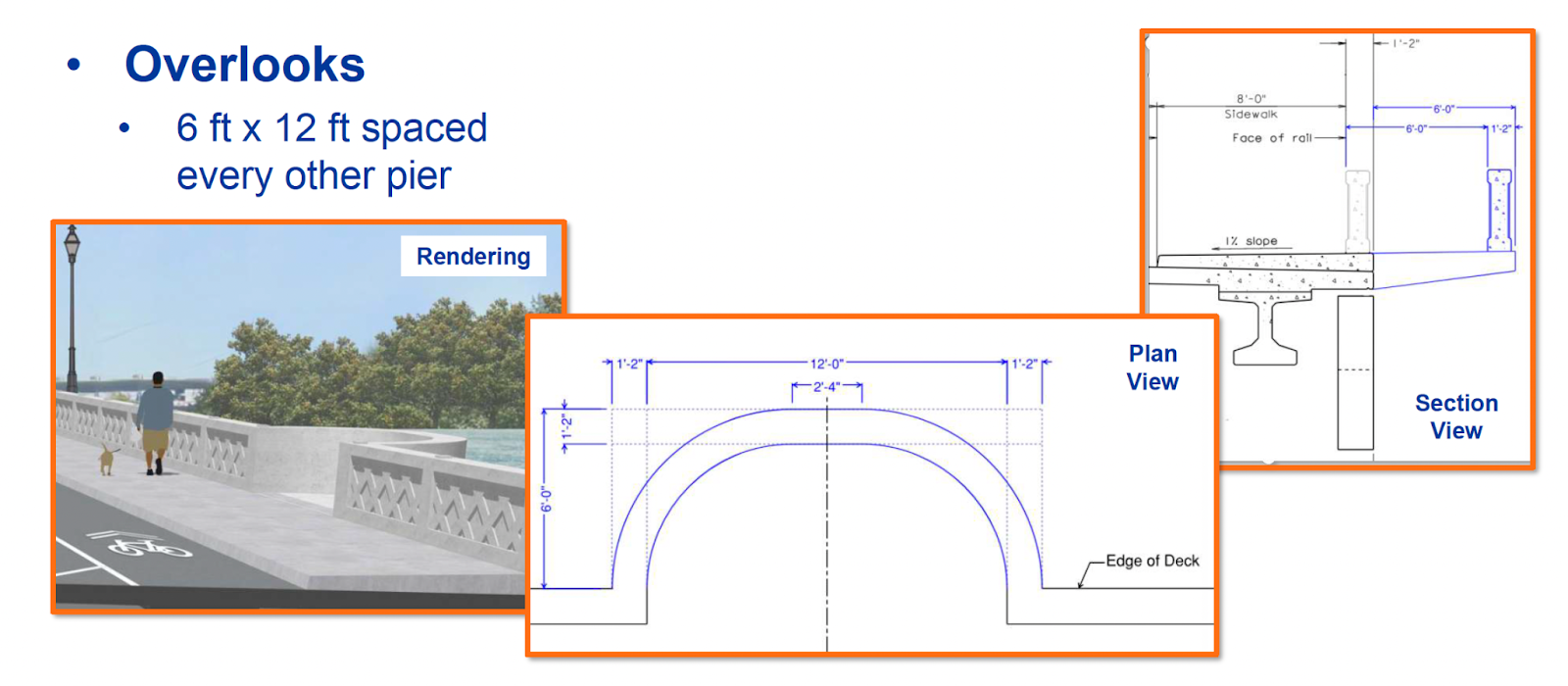
New pedestrian overlooks
A new feature that could be introduced to the bridge is a series of overlooks that would let pedestrians stop to admire the river, rest and potentially even fish off the side.
The rounded overlooks would protrude 6 feet out over the river and would be 12 feet wide, placed at every other bridge pier. Wheeler noted that a similar design is used on the Pont Neuf in Paris, one of the most iconic of that city’s bridges.
Modern engineering overlaid with historic design
Another major point of discussion, and some confusion, was to what extent the new Mayo Bridge ought to mimic the existing one.
While not identical to the current structure, the plans presented Thursday would produce a bridge that closely resembles it, with a wide expanse of travel lanes and sidewalk flanked by low decorative walls.
Instead of having obelisks at regular intervals along the whole bridge, they would be placed only at the corners of the bridge, with four on the span that lies north of Mayo Island and four on the span that lies to the south.
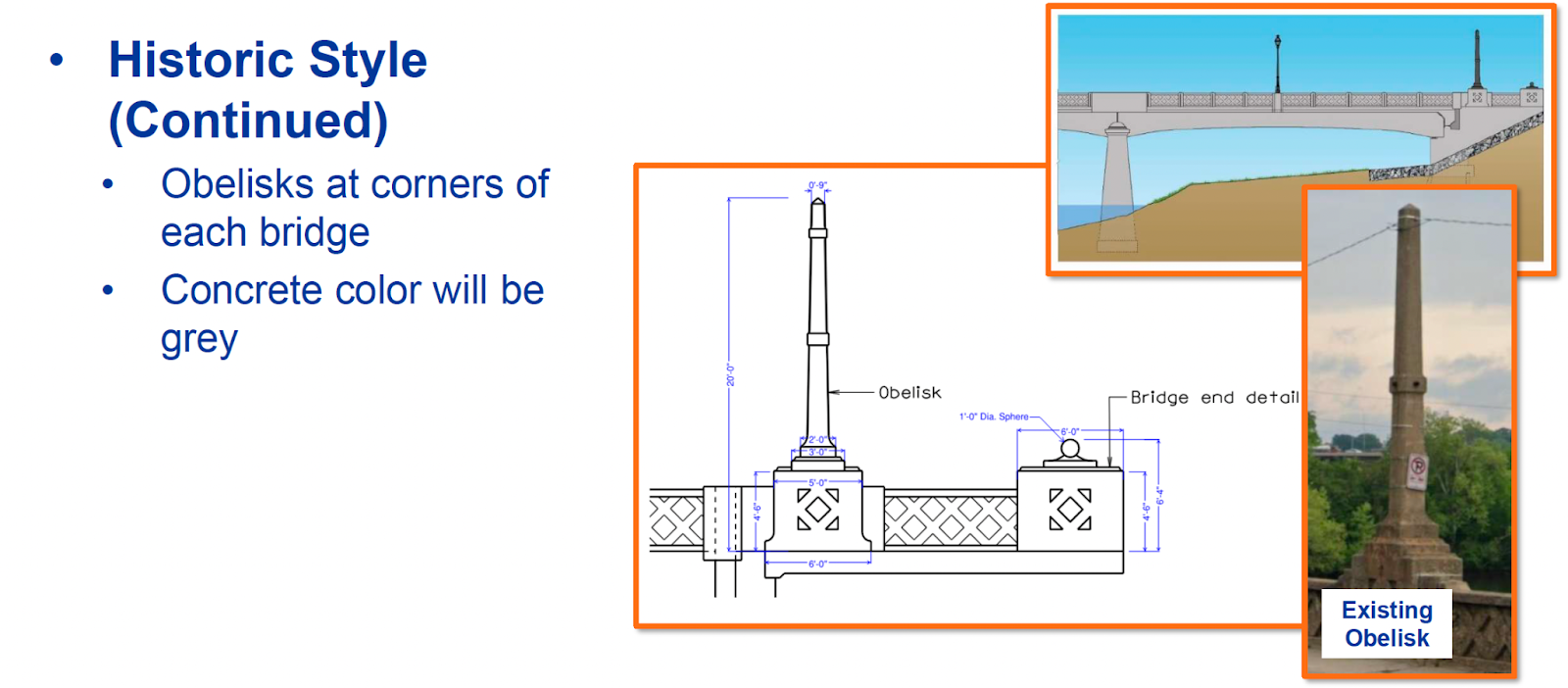
The city’s Riverfront Plan, which was adopted by the City Council in 2012 as part of Richmond’s master plan, calls for any reconstruction of the Mayo Bridge to “maintain the historically accurate architectural appearance of the existing Mayo Bridge.” Kim also said a 2011 survey found that 85% of people wanted a rehabbed bridge to mimic the old one.
Wheeler said the plan is to rebuild the bridge with a modern structure that is easier to maintain and then overlay it with a historic facade that will meet federal historic preservation standards. As a model, VDOT and Richmond officials are looking to the Southgate Drive bridge over U.S. 460 near Virginia Tech.
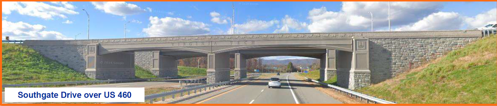
“The further we move away from matching the historic style of the existing Mayo Bridge, the more challenging it’s going to be to get this through” federal review processes including Section 106 review, said Wheeler.
But Spencer Grice of the Shockoe Partnership questioned whether trying to match the existing structure was the best path forward.
“When this bridge was originally going to be a repair, I understood the impetus to restore what was there,” he said. “But when this bridge became a replacement, to me that is the time to look at what is the new opportunity for a piece of infrastructure that will serve the city and citizens for the next 100 years.”
UDC member Timothy Hamnett said the plans were “not a very grand vision.”
“It looks like every other darn bridge that you pass by,” he said. “It is not a big move.”
The conceptual plans will next go before the Planning Commission Tuesday, which will consider the recommendations from the UDC as well as suggestions from planning staff.
Contact Reporter Sarah Vogelsong at svogelsong@richmonder.org